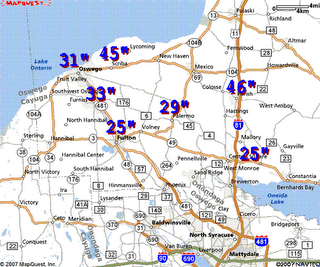
WeatherT who is a schooled meteorologists posted some stats and a map of some of the totals from up north which are below. The funny thing is that I expected to wake up and see that Buffalo had buried us in the snow totals because there is a lot of snow falling all around them also. Mostly some towns to the south of them which should have some decent totals to report also. The chances are that some of the people in Buffalo were expecting Syracuse to maybe pull ahead the way the lake effect was knocking on their door yesterday. Well Syracuse never opened the door and only picked up a couple of inches. Once again it still amazes me after living in the Syracuse area all my life how localized our snow bands can be. Below are some stats that WeatherT gathered up which are impressive and the scary part is that there is no sign of it letting up. Have a great day all and for those of you in the Snowbelts right now, Good Luck and stay safe.
Click Snow Map to Enlarge
Some stats posted in the forum from NOAA for OSWEGO COUNTY…
SCRIBA 45.0 600 AM 2/6 27″ LAST 12 HOURS
PARISH 46.0 214 AM 2/6 HEAVY SNOW VSBY 200 FT
OSWEGO 31.0 600 AM 2/6 CITY OF OSWEGO
PALERMO 29.0 515 AM 2/6 BAND MOVED SOUTH
WEST MONROE 25.0 600 AM 2/6 11″ LAST 12 HOURS


