Archives

All posts for the month December, 2012

I just did an update on the snow stats and see that Binghamton has been making out pretty good with this snowfall.  They jumped from 4th place up to 2nd on the snow hill bumping both Rochester and Buffalo down.

After the slow start we have had the snow contest is starting to take shape and 3 of the Golden Snowball cities are within an inch of each other.  Most of us have made up quite a bit of snow last week to get closer to our normal averages for the season.  Here are the snow totals for yesterday.

Binghamton – 6.4
Syracuse – 4.7
Rochester – 4.2
Albany – 4.0
Buffalo – 2.9

Enjoy the rest of the weekend and rest them backs, that’s what I will be doing today.  Well, after I shovel one last time 😉

Someone mentioned to me the other day about how nice last winter was.  Of course I replied with that depends on what you consider nice.  He then mentioned how we got most of our snow in December and then nothing after that.  I mentioned to him that most of December was pretty lame as far as snowfall went.

Just looking at the chart and last season snow stats to date it really shows how lame it really was this far into December.  With all of the cities below their average total snowfall to date, we are all blowing away last seasons totals to date now.

I think that’s what makes this contest so much fun to watch throughout the winter.  We all know that all it takes is one or two decent snow storms to change the season around and also to decide who is on top of the snow mountain.  It looks like the bell rang for round 3 looking out the window and seeing the snow come down.

Go Orange Football, Go Orange Basketball.  Can a day of sports get any better than today?  Well if Duke was to lose then yes 😉

Have a Great Day All…

Another quick update – The Syracuse snow stats were just posted a little while ago.  They are showing 7.9 for today bringing their 2 day storm totals to 12.5 inches of new snowfall.  The chart is as up to date as the National Weather Service is now 😉

Updated 12/27 – The new snow stats were just posted with the exception of Syracuse which is showing MM meaning the stats aren’t being reported yet.  Surprisingly there were no changes in the lineup and the totals although pretty decent were a little lower than I expected them to be.  Here at my house east of the city of Syracuse I measured 13 inches of snow.  Buffalo took the honors with this snow storm picking up 12.3 inches of snow for the 2 days.  That is unless Syracuse can top it when an update for them comes out.  Here is the way it all played out the last 2 days and keep an eye on my fuzzy math 😉

Buffalo – 12.3 inches
Rochester – 11.1
Syracuse – 12.5
Albany – 7.8
Binghamton – 6.3

——————————————————-

6:00 AM Update – I just updated the snow stats and they are from what has fallen as of yesterday so far.  No doubt this has been a decent storm because I can tell by how many cars come into the yard taking the turn 🙂 2 so far for this storm with the last one being about an hour ago.  One was able to get out on her own and the other one was buried pretty good so we were able to get him shoveled out about 4 am.  Time for a nap and it will be interesting when the next update comes out. So as of the end of yesterday the storm totals are and don’t let them fool ya just yet, many more inches to be added to some of the cities 😉  Good Night

Buffalo – 10.1
Rochester – 8.5 Record
Binghamton – 5.1
Syracuse – 4.6
Albany – 2.9

——————————————————–

10:30 PM Update –  As of right now Syracuse and Binghamton are the only cities that have updates out thanks to the Binghamton NOAA station.  Buffalo and The Rock normally come out around 2:00 am give or take so you may not see them posted until tomorrow.  Right now Binghamton is showing 4.1 and Syracuse is reporting 3.8 as of 10 PM for this snow storm.  Any Guesstimates as to which city will have the highest totals for this storm?  I’m going with –

Rochester – 15.5
Syracuse – 13.0
Buffalo – 11.5
Binghamton – 11.0
Albany – 8.5

————————————————————-

Winter storm warnings are / will be in effect for all of the Golden Snowball cities so if you need to travel you should do it early.  From reading around at the National weather service most of the heavy snow won’t be starting until later on for some of the cities.

Most of the forecasts are calling for at least a 8 – 14+ inches of snow between tonight and tomorrow afternoon.  They are also saying we can expect 2 – 3 inches an hour at times which is a lot of snow coming down and normally will stop traffic.  In other words as much as we are use to the snow you should stay off the roads for this storm.  Keep an eye on your favorite news channel for changing conditions and take it slow.  Below are links that will get updated by the National Weather Service as the snow storm gets closer.

Warnings for the Buffalo and Rochester Areas

Warnings for the Syracuse, Utica and Binghamton Areas

Warnings for the Albany and Surrounding Areas

Most of the Cities and Counties in New York

Have a Great Day Everyone and Stay Safe 😉

PM Update – Well Rochester’s move into 3rd place was short lived.  The 5pm stats just came out and Buffalo had just enough to move back into 3rd.  Syracuse is showing another 3.2 inches for today so far which puts them over the one foot mark for the 2012 – 2013 snow season.  It’s looking like a white Christmas for a few of the cities 🙂

————————————————————————–

Syracuse was able to claim the top spot on the snow hill picking up 7.6 inches of snow yesterday and a few more inches today.  Last seasons snow champ Rochester knocked Buffalo down a spot with their 4.3 inches of snowfall. Looking at the forecast for the next week or so it looks like there could be a lot of changes coming up in the lineup.

I don’t think the overnight snow totals are added in the stats we just posted so chances are the totals should be going up a little higher.  Yesterday was an awesome day here in the Syracuse area as far as the snow goes.  IMO there is nothing like a decent amount of snow along with some pretty gusty winds and I couldn’t wait to get out in it yesterday and last night.  It was nice hearing the sound of the snow plow dropping the blade at around 4:32 in the morning.  It was also nice to see the sleds at my local watering hole last night 😉  I’ll try to get another update in later on when the stats come in.

Have a great day everyone 🙂

10 PM Update –  It looks like Syracuse slipped into the lead but we’ll wait until the stats come out tomorrow for all of the cities.  The stats are updated as of between 4:00 and 5:00 Pm for today with Albany not reporting.  Just off and on light snow in the Syracuse area so come tomorrow the king of the snow hill may still be up for grabs 😉


Firts off – WE’RE ALIVE 🙂  The Mayans had me sweating it out for awhile there, lol.  Happy Winter All!

Just a quick update for now seeing how most of the stats are from just yesterday and not the overnight.  .Buffalo grabbed enough snow to jump past Syracuse into 2nd place.  WTG Buffalo and is this your season to take the golden prize?

Right now it looks like there is about 5 inches on the ground so far in Syracuse. Hopefully another 3-6 inches to come by the time it settles down. After the slow start we all have had so far there is a lot of snow totals to make up to get back to a normal season. I’ll get another snow total update in later when the National Weather Service posts them. GO SU!!!

Just a heads up that I started up the National Snow Contest a couple weeks ago. The national snow contest is called the Golden Snow Globe and is for any city in the United States with a population of 100,000 + You can check it out HERE at the golden snow globe website.

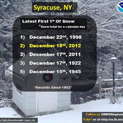
Right now Rochester and Syracuse are knocking on the door of less than an inch of snowfall in one day record.  In other words both golden snowball cities haven’t gotten an inch or more so far this season.  The latest Syracuse has ever gone without an inch in one day is December 22nd.  As of yesterday this has been the second longest they have gone.

Rochester’s will break their latest snowfall total of less than an inch if they can hold off the snow until the 22nd.  The latest they have gone is Dec. 21st which was back in 1939.  This will be their 2nd best without an inch if they make it through today.  With snow in the forecast in the next couple of days it will be interesting to see if either of the cities can do it.

LATEST DATE OF ONE INCH OR MORE SNOWFALL IN ROCHESTER
1       DECEMBER 21 1939
2       DECEMBER 19 1927
3       DECEMBER 17 1998
4       DECEMBER 16 1979
5       DECEMBER 15 1948

LATEST FOR SYRACUSE courtesy of the Binghamton National Weather Service