Archives

All posts for the month December, 2016

First, as always, a Big Thank You to Donald R for your donation to the Golden Snowball site. It was the first donation of the season to the Golden Snowball site and it really helps out. I Truly appreciate it and Thanks, Donald 🙂
—————————————————————-
Updated 12/30 6 PM – OK, the new evening snow stats are out and they show Syracuse has taken the lead from Binghamton, again. Or maybe it’s the 1st time this season, who knows and I guess it doesn’t matter much. The snow that was taken away from yesterday’s totals wasn’t added in this update so it looks like it was an adjustment made to the totals yesterday. More below about that and Congrats Syracuse!!!

—————————————————————–

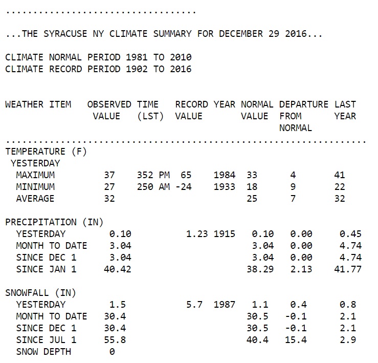
Updated 12/30 Noon – Hold on Syracuse, not so fast! I wake up this morning and I check the new snow stats to see if any of the cities had more snow to add for yesterday. When I look at the Syracuse snow totals from the National Weather Service in Binghamton I see that they were lower than what was posted at around 10pm last night.

I’m guessing that the NWS either made an adjustment or maybe just made an error on the last update they put out. We will know a little later this afternoon when the next update comes out at around 5pm give or take a little. I put Binghamton back on the top for now as I always go by what the NWS is showing on their site. Below are a couple of screenshots of the snow stats to let you all see what I see. Careful driving today!
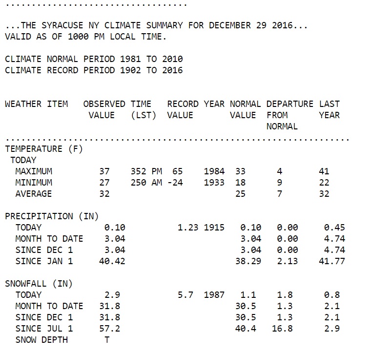
syracuse-snow-totals-12-29-10-pm

syracuse-snow-totals-12-30-1-am

Posted 12/29 11pm –

Syracuse leads Golden Snowball Contest for 1st Time This Season

Syracuse, NY has finally slipped passed Binghamton to take the Top spot on the snow hill for the 1st time this season. As of the last update at 10:00 PM, 12/29 from the National Weather Service yesterday, Syracuse was reporting 2.9 inches which was just enough to slip past Binghamton, NY which was reporting 2.5 inches as of 10 pm.

Syracuse was trailing Binghamton by 2 tenths of an inch at the end of Wednesday, 12/28 and has been behind Binghamton all season long. Binghamton has been in the lead most of the snow season other than a brief period when Albany, YES Albany, was on the top of the snow hill. Binghamton has already passed the total snowfall that they had for all of the last season, 2015-2016, which was only 32.0 inches. As of the last update, Binghamton is showing 57 inches of snow so far this season.

Syracuse as of the last update from the NWS is showing a snow total of 57.2 for the season which is just enough to take the lead from Binghamton. Right now it’s still snowing and chances are pretty good that the lead will grow today and tonight with more snow expected.

Stay tuned and I’ll be posting updates right here as the National Weather Service keeps putting them out. Keep in mind that the snow falling is Lake Effect snow so it can change at any time. Stay safe and take it slow on the roads.

Binghamton Likes it On Top of the GSB Snow Hill

OK, Binghamton, NY has once again defended the Top spot on the Golden Snowball snow hill. Binghamton was able to not only hold off today’s charge up the hill by Syracuse, NY but was able to push them back down a little further. WTG Bingo!

Syracuse was able to close in on Binghamton the last day or so and was only 2 tenths of an inch away from reaching Binghamton. I was watching the radars thinking Syracuse may have slipped into the top spot today but it turns out that Binghamton won this snowball fight picking up 2.5 inches of snow so far today compared to Syracuse’s 1.4 inches so far. This is as of 5 pm according to the National Weather Service.

City Snow Totals From Yesterday, 12/27

    * Binghamton – 2.5 inches of snow
    * Buffalo – 2.5 inches
    * Albany – 2.1 inches
    * Syracuse – 1.4 inches
    * Rochester – 1.1 inches

    Binghamton King In The Golden Snowball Contest So Far

    It will be interesting to see what the rest of tonight has in store and also the next couple of days. If I were a betting man, oh yeah, I am 🙂 I think I’ll be putting my money down on Syracuse to gain the lead come tomorrow evening snow update. Syracuse has lead the National Golden Snow Globe contest for a good part of the snow season but has yet to lead our great NY Golden Snowball contest this season.

    Click Here for the National Golden Snow Globe Contest

    Binghamton started the 2016-2017 snow season off in the Golden Snowball contest in 1st place back on October 27th picking up an inch of snow. So far this season Albany (Really) was the only other city to hold the top spot in the snow race.

    Buffalo, believe it or not, has been in last place a good part of the snow season up until the last couple of weeks, give or take. Buffalo didn’t pass the 1 inch of snow mark until around December 6th or 7th but seem to be getting on a roll now.

    Rochester, NY, the only city that has beaten Syracuse since the Golden Snowball contest started up again seems to be content right now at just hanging in the middle of the pack. The best thing about this season so far is that, that, that it’s only just begun 🙂

    Click Here for the current snow stats!

    Keep and eye on your weather the next few days because there is a good chance it is or will be a little nasty. Check your favorite pros for you forecast and stay safe. Have a Great night All!

Binghamton, NY Keeps Piling on Snow Totals

I was just noticing that Binghamton, NY already has over half of their average total snowfall for the season already. Binghamton’s entire seasonal snow total on average is 83.4 inches of snow. Right now Binghamton has 47.8 inches of snow and chances are they will be getting more today. Only 35.6 more inches to go for Binghamton to hit their average snowfall for an entire season and Winter hasn’t even started yet.

Binghamton Has More Snow To Date Than Ever Before

This is the most snow Binghamton, NY has ever had at this time in the season if my math is right. Keep in mind my fuzzy math, though, it normally isn’t as most of you know by now 🙂

Binghamton is blowing away the highest snow totals they have ever had on this date, December 14th with 47.8 inches of snow right now. More than 10 inches of snow higher than the 2nd highest to date. The 2nd highest snowfall that Binghamton has had at this time in the season was 36.6 inches on December 14th, 1977.

This season Binghamton has been ahead of their all-time highest snowfall totals to date record almost all season starting on November 19th. I’ve said it more than once and I’ll say it again. It takes a lot to impress me as far as snow goes and Binghamton is impressing me big time this season. WTG Bingo 😉

Binghamton is already crushing the snow totals for the entire 2015-2016 snow season. Of course, last season Bingo only had 32.0 inches of snow and it was the lowest ever on record for Binghamton.

The only season I saw that came close to a time when Binghamton had this much snow so soon in a season was the 1993-1994 snow season. Even that season it took until January 4th for Binghamton to have as much snow as they do right now. WOW! The wow is because 1993-1994 snow season was Binghamton’s highest seasonal snowfall on record which was 131.3 inches of snow.

Binghamton still has a long way to go to hit the all-time high seasonal snow totals of 131.3 but they are off to a really good start. Could this be a repeat of that season?

Heavy Lake Effect in Forecast, Stay Safe

There are a few advisories and warnings out for the next day or two with the colder air coming into the area so check with the pros. It looks like you folks in Buffalo may be getting hit pretty good with some lake effect snowfall and no doubt it’s will be a nasty rush hour ride home. Stay safe all and have an Awesome day. See Snow-Drive Slow 😉

WOW! If my math and stats are right (normally are a little iffy 😉 ), Binghamton, New York already has more snow for the 2016-2017 snow season than they had for ALL of their last season (2015-2016). According to the National Weather Service out of Binghamton, they are reporting 3.1 inches of new snowfall for today, 12/6. That brings Binghamton’s snow totals for the 2016-2017 snow season up to 32.9 inches so far and counting with pretty much the entire season ahead of us.

For the entire 2015-2016 snow season which begins July 1st and ends June 30th Binghamton only had a seasonal snowfall total of 30.0 inches. I have to say that I am impressed that it’s only December 6th and Binghamton has already surpassed their entire snow seasons totals. WTG Binghamton and keep piling it on 😉

2015-2016 Snow Season – 30.0 inches of snow.
2016-2017 Snow Season – 32.9 inches of snow.

Click Here for All of The Current Snow Totals

WTG Binghamton 🙂

Snow Here, Snow There, Snow Everywhere

Lake effect watches and warnings are starting to be posted by the National Weather Service now for some of the GSB cities and the surrounding areas for when the colder air comes in on Thursday and Friday. You all know I am clueless so check with the pros in your area for the latest update. I have a couple links posted below for the Rochester and Syracuse areas that are worth checking out and I’ll keep this post updated the next couple of days.

All of the Golden Snowball cities received some snow yesterday and it’s only going to get snowier later in the week for some of us. Binghamton, Syracuse, Rochester and even Buffalo and Albany got some fresh snow yesterday. Sorry about that dig to the folks in Buffalo but I need to get it in now because I know it’s only a matter of time before you are back in the snow race. Maybe sooner rather than later 😉

Binghamton cushioned their lead over last season’s snow champs, Syracuse yesterday picking up 0.9 inches while Syracuse picked up 0.5 inches of new snow. I know it’s not a lot but we all know every tenth of an inch counts in the long run. Albany won the round yesterday picking up 1.4 inches which was more than enough to keep Buffalo at the bottom of the snow hill. Below are the snow totals for yesterday.

Albany – 1.4
Binghamton – 0.9
Rochester – 0.9
Syracuse – 0.5
Buffalo – 0.3

Lake Effect Snow Forecasted For End of The Week

I’m starting to see reports of some decent Lake Effect Snow expected to come Thursday and Friday for some of the Golden Snowball cities. You know it’s all about fun here and that I am clueless so check with the pros for the latest forecast in your area. Here are a few of the forecasts with watches and warnings that have been issued so far. Click on the links below for the most recent watches and warnings.

Some of the snow totals from Lake Effect snow are expected to be a foot or more of snow for some of the cities so definitely keep an eye on your local weather. Below is as of 12/6 at around 2:00 PM. I guarantee most of this will be changing as the colder air comes in so save the link and keep up to date. These are from the National Weather Service stations in our areas.

Rochester – Lake Effect Snow Watch in effect from December 8, 06:00 PM EST until December 10, 06:00 AM EST Click here for more info on Rochester!

Syracuse – Lake Effect Snow Watch in effect from December 8, 06:00 PM EST until December 10, 06:00 AM EST Click here for more info on Syracuse!

I’ll keep posting updates as the National Weather Service puts them out. Like I mentioned above, your best source is your local forecasters. Have a Great Day and as always, See Snow – Drive Slow, unless you’re riding a sled of course 😉