Archives

All posts for the month November, 2013

I just received an email from Cynthia from Madison, WI who grew up in Syracuse sending me a link about Scientists and researchers from several Universities and institutions coming to the shores of Ontario Lake to study what’s going on with Thundersnow during Lake Effect Snow events.  SUNY Oswego is also participating in the study and research 🙂

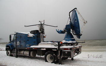
The project is called OWLeS which stands for Ontario Winter Lake Effect System’s and will be taking place this snow season on the shores of Ontario lake.  What will be cool is some of the high tech equipment they will be bringing with them.  Most likely if you’re in the Oswego and surrounding areas you will be seeing this flatbed truck below which is called Doppler on Wheels or DOW.

Doppler on Wheels research truck

Doppler On Wheels

 Doppler on Wheels Picture From The National Science Foundation

They will also be bringing and aircraft equipped with instruments from the University of Wyoming called the King Air so keep an eye in the sky for the scientists who fly.  Yeah, I’m a poet, not 😉  Anyways this should be pretty cool for the people to watch not to mention the amount of information that will come out of this research to help in the future on narrowing down and predicting more precisely where Lake Effect snow may hit, when and for how long.

The dates for this study according to the article on the NSF, National Science Foundation website that Cynthia sent me will be from Dec. 5-21, 2013, and Jan. 4-29, 2014.  Thanks for the info Cynthia and you can read a lot more about this on the National Science Foundation’s website at http://nsf.gov/news/news_summ.jsp?cntn_id=129618&org=NSF&from=news .

Have an Awesome Weekend and Hopefully a Snowy One 🙂

Nothing new to report other than so far we are all having a below average sissy kind of snow season.  Binghamton continues to lead the Golden Snowball contest and Albany continues to trail the rest of the pack.

All of the cities have less snow than normal for this time of the season but all of the cities other than Albany also have more snow than last season at this time so far.  So you ask me what does all of this mean?  I tell you I don’t have a clue what it all means 🙂  I do believe however that it is going to be a cold snowy 2013 – 2014 season or for most of it anyways.  Here is the difference between the normal snowfall for this time of the year and what we all have so far.

Albany – – Minus 0.9 inches

Binghamton – Minus 1.2 inches

Buffalo – Minus 3.3 inches

Rochester – Minus 1.0 inches of snow

Syracuse – Minus 3.3 inches

So in other words for you snow haters out there, enjoy the wimpy 2013 – 2014 snow season that we have had so far.  Father Winter is just taking it easy and planning out what he has in store for us down the snowy road 😉

Have an awesome day all 🙂

Go Binghamton!  Binghamton has taken the lead in the Golden Snowball contest slipping past Rochester by a couple tenths of an inch of snow.  I saw some pictures earlier on the Binghamton National Weather Service Facebook page earlier and had a feeling that they may be the new leader.  WTG Binghamton 🙂

Speaking of the Binghamton National Weather Service they are giving an online class tonight at 7:00 PM.  The classes are very informative and they cover a lot including how to measure the snow and how to be a snow spotter which helps them out.  There may still be time to register so check it out if you have some time in a little bit.  Info is below from NOAA

———————————————–

Just a reminder that our second online winter weather spotter class is tonight starting at 7 PM.  You have to register if you want to join us.  You can do so here: https://www2.gotomeeting.com/register/813782794  You must have a computer with internet access and a phone to participate.  -Erik.

Rochester is the first city to pick up over an inch of snowfall this season picking up 1.2 inches of snow yesterday.  They have doubled the amount of snowfall over the new 2nd place spot which is held by Buffalo now.  Really, Buffalo is near the top go figure 😉

It seems like forever ago that Buffalo was near the top of our snow contest with the last couple of years being pretty wimpy winters for them.  They had their first snowfall of the 2013 – 2014 snow season yesterday picking up 0.7 of an inch.  Binghamton also had their first snowfall showing 0.2 inches of snow for yesterday which was just enough to put them in a tie with Syracuse, last seasons champ.  Nothing to show for Albany!

This was the first lead change of the new snow season and no doubt it’s game on right now.  I’m thinking there will probably be a lot of lead changes this season and I also have a feeling a few of our cities are going to get hammered this season.  Hammered by snow that is 😉  More updates to come soon.

We also had another lead change in the National snow contest which I believe is the third lead change for the snowiest big city.  You can check out those snow stats at The Golden Snow Globe Site.

Have a Super Awesome Day All and as always, “See Snow, Drive Slow”.

Let the games begin!  Syracuse has started the new season with a wimpy 0.2  of an inch of snow but enough to get things started 😉   This is the first measurable snowfall of the season.  Well I was starting to sweat out my last post about the snow season and the Golden Snowball contest starting up.  Thank God NOAA came through with some snow stats, measurable snow stats to start the season up.

Albany is showing MM right now which means they haven’t reported yet or don’t know what to report yet.  I was surprised to see just a trace of snow with the other GSB cities expecting at least Binghamton to report some measurable snowfall.

Then I went into panic mode when Brian Cubbison from the Post Standard posted something about the contest based on my earlier post for the fact when I looked at the stats earlier no snow was being reported yet.  OK, Enough rambling and it is official now 🙂  Let the snow games begin 😉

Have a Super Day All 🙂

I finally woke up this morning to see some of that white fluffy gold in the sky falling and even sticking to the ground a bit. I figured a couple tenths of an inch where I live which is just outside of the city of Syracuse and not too far from the airport where they measure the snowfall for Da’Cuse. It also looked like it was snowing down toward Binghamton’s way so there is a good chance that we may have Liftoff for the new 2013 – 2014 snow season. The question now is which city/cities started it up this season?

How about Rochester or Buffalo? Any snow to report there today? From what I have been reading it’s suppose to be a cold winter this year which could mean some decent Lake Effect Snow for some of us. I’ll post an update later this afternoon or evening when NOAA posts the new stats from earlier today. Remember, ALL of the stats are courtesy of the national weather service and to this day it still amazes me how much info they have on their website.

On one other note there is a rumor going around about a big storm come the end of next week. After reading around about that it seems that right now it’s WAYYYY to far for the pros to predict but if everything falls in place perfectly it is a possibility that it just may pan out. Chances are they won’t be able to pin it down until some time next week so I wouldn’t worry about it just yet or is that I wouldn’t get excited about the Nor’easter just yet 😉

Have an Awesome Day All 😉