Lake Effect Snow

Syracuse was the king snowman yesterday so far picking up 4.5 inches of the white fluffy stuff yesterday.  At least I hope it is fluffy and not wet heavy snow because I haven’t shoveled yet.  Syracuse tied the date record of 4.5 inches going back to 1981.  Albany finally got a peak at some snow picking up 0.4 inches.

Like a little kid I get all excited with the first decent snowfall of the season and went for a ride in the middle of a decent snow band that was hitting.  The roads were slick with a few whiteouts from the windy lake effect snow band.  I guess that it what makes LES so cool.  The way the wind really picks up and how much snow can fall in a short amount of time when the snow band sets up over your house 🙂  Of course I say I am like a little kid the first snowfall but I’m really like a little kid every time a storm or good lake effect snow hits.  OK, maybe not so much so come around March when the shoveling starts getting a bit old.

I stayed up until around 2:30 this morning waiting for the new snow totals to come out from NOAA for Buffalo, Rochester and Albany so I would have a nice update this morning for you all buttttt.  When the stats came out for those 3 cities all I saw was MM which means that they were missing the data.  Wasn’t too happy about that of course and I wasn’t staying up until the 5am update, sorry about that.  Then again overall NOAA is awesome with all of the information and stats they collect and post so I’ll stop my whining 😉

The new totals include the snow from yesterday so they will be changing as the snow stats come in today and later tonight.  I should be able to get at least one more update in later and we will see if all of the cities have more to add.  My guess is they will.

A Picture From 11/23/2013 of Snow in Minoa, NY

Minoa, New York Snowfall

Enjoy your Sunday All and Drive Safe!
Syracuse finally got some lake effect snow to help push them to the top of the snow hill.  So far they are showing 2.5 inches of snowfall for the day to put them at the 3 inch mark.  Just enough to take the lead from Binghamton who has been sitting at the top for awhile now.

Snow is still in the forecast so it should be interesting to see what later tonight and tomorrow drops on the Golden Snowball cities.  Will Syracuse be able to hold the lead by the time the Lake Effect Machines start slowing down.  Should be interesting 😉

Then there is the possibility of a storm hitting the East Coast sometime this week.  From what I have been reading the National Weather Service should have some kind of idea toward the end of this weekend as to how that storm will pan out and which cities it may effect.  Makes me wonder if Albany may have an advantage with this one if it happens.  More updates to come as the snow stats come in from NOAA.

Have a Great Night All 🙂

I just received an email from Cynthia from Madison, WI who grew up in Syracuse sending me a link about Scientists and researchers from several Universities and institutions coming to the shores of Ontario Lake to study what’s going on with Thundersnow during Lake Effect Snow events.  SUNY Oswego is also participating in the study and research 🙂

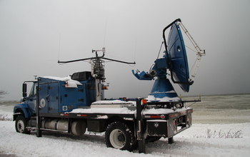
The project is called OWLeS which stands for Ontario Winter Lake Effect System’s and will be taking place this snow season on the shores of Ontario lake.  What will be cool is some of the high tech equipment they will be bringing with them.  Most likely if you’re in the Oswego and surrounding areas you will be seeing this flatbed truck below which is called Doppler on Wheels or DOW.

Doppler on Wheels research truck

Doppler On Wheels

 Doppler on Wheels Picture From The National Science Foundation

They will also be bringing and aircraft equipped with instruments from the University of Wyoming called the King Air so keep an eye in the sky for the scientists who fly.  Yeah, I’m a poet, not 😉  Anyways this should be pretty cool for the people to watch not to mention the amount of information that will come out of this research to help in the future on narrowing down and predicting more precisely where Lake Effect snow may hit, when and for how long.

The dates for this study according to the article on the NSF, National Science Foundation website that Cynthia sent me will be from Dec. 5-21, 2013, and Jan. 4-29, 2014.  Thanks for the info Cynthia and you can read a lot more about this on the National Science Foundation’s website at http://nsf.gov/news/news_summ.jsp?cntn_id=129618&org=NSF&from=news .

Have an Awesome Weekend and Hopefully a Snowy One 🙂

I’ll be crunching numbers for those of you who entered to win the Autographed book “Lake Effect” signed by author Mark Monmonier.  From taking a quick look at some of your snow stats that you guesstimated I can tell you that it’s pretty close between a handful of you.

OK, barring any fuzzy math on my part here are the entries that were pretty close to each other along with the winner of the contest.  Thanks to all of you who entered 🙂

Stephen – 261.7 off by – 18.5
Kimberly – 299 off by –   18.8
Peter – 258.4  off by –     21.8

The winner and not by much is
* Don who had 297.5 and missed by 17.3 inches of snow.

END OF FUBRUARY TOTALS

Syracuse – 83.2
Rochester – 63.8
Binghamton – 53.8
Buffalo – 48.7
Albany – 30.7

Total = 280.2

The snow totals above is what NOAA, The National Weather Service has reported as of the end of yesterday.  So the magic number to hit or be closest to after adding the totals of the 5 Golden Snowball cities comes out to 280.2 inches of snow.

UPDATED – I just heard from our national weather service and it looks like Syracuse picked up only 3 tenths of an inch so far this season.  Let’s see how the overnight

The snow stats have just been updated but as of around 5PM Syracuse hasn’t reported their totals yet for the day. There is a good chance the lineup may change come the next updated later this evening come the next update.  I was surprised that Buffalo was just showing a trace still thinking that the band that went to the south of them this morning must have dropped some measurable snowfall.  We’ll see how it all turns out come tomorrow.

Here in the Syracuse area it’s been pretty blustery most of the day.  Snowflakes have been falling off and on most of the day but so far other than this morning not much to talk about as far as snow totals go.  For myself, today has seemd the coldest day so far this season mainly because the temps are low and the wind has been blowing pretty good.

If I’m around later I’ll try to update the stats again to see how all of the cities stand on our snow mountain.  I have a feeling that Binghamton is going to stay on top but after that it should be interesting 😉

Have a Super Night All and watch out for some black ice tonight.  See Snow – Drive Slow

Updated 1/14  6:30 am – All of the Golden Snowball Cities are up to date 🙂

——————————————————————————–

Updated 1/14 1:00 am – All of the snow stats for the day haven’t been reported yet.  Syracuse and Binghamton are valid as of 10 PM, Albany didn’t report the last update and Buffalo and Rochester’s snow stats are only up until 4 PM.  Chances are that Albany, Buffalo and Rochester will have some (maybe a lot) more snow to add come tomorrow morning.  The snow is hanging just north of Syracuse trying to slide toward the city so they may have more to report also.  Here is what we have so far according to NOAA.

Syracuse – 8.0 Record – Old Record 6.1 in 1989  They also set a rain record for the day.
Buffalo – 6.4 Record – Old Record 5.1 in 2000
Binghamton – 5.5
Rochester – 5.5
Albany – Trace?????

————————————————————————————-

Start the GSB snow contest TAKE TWO – Let’s restart the contest all over like it never started to begin with. Here we are just about half way through January and only a foot of snow is leading the snow contest. Only a foot of snow for Syracuse which has held the bragging rights for the past several years as the snowiest city in the Golden Snowball contest.

Albany, which I consider the place to go in the winter to get away from the snow actually has a realistic chance right now of winning the contest. It would be the first time ever for Albany. They added another 2.6 inches of snow today to add to their totals for the season. Enough snow to slip past Rochester and go into 3rd in the snow contest. Albany in 3rd place in the middle of January just don’t seem right does is? Well, way to go Albany I suppose. Makes me wonder what Governor Cuomo
has up his sleeve 🙂

Make sure ya’s check out Stephen’s Point Blank Range Forecasts below 🙂

Right now the Golden Snowball Trophy is up for grabs for any of the cities. Snow is in the forecast for all of the GSB cities I believe and come the end of the weekend (probably sooner) there may be a new leader. I’m taking a guess that come the end of the weekend (Sunday Night) it will be

Rochester
Syracuse
Albany
Binghamton
Buffalo

Which city do think will be winning? Leave a comment with what you all think the line-up will be come the end of Sunday.

Take it slow driving and have a Super Day All 😉